Friday, November 26, 2004
Checking In... Checking Out
Sorry for the lack of progress here. Been up to my ears in real-life stuff. Check out El Savior's site this week - sounds as if he is getting close to releasing "Seven Roads to Hell."
Sunday, November 07, 2004
Crouching Panther, Screaming Eagle
Now that I know COTA will not support the HTTR maps and scenarios, I've decided that my Carentan map is good enough and ready for a scenario (why try to perfect something that I'll only have to recreate when COTA is released).

To that end, I'm putting together battle that pits the 101st AB against a PZ Div. It's fiction - but fun. Will take me a week or more to get it ready. Stay tuned!
To that end, I'm putting together battle that pits the 101st AB against a PZ Div. It's fiction - but fun. Will take me a week or more to get it ready. Stay tuned!
Wednesday, October 20, 2004
AAHQ Update
I started out using this blog to talk about my modifications to the HTTR game, specifically the Hedgerows mod. But, I've been monitoring the site using "Statcounter" and very very few people bother to read the posts about map creation and estab creation etc. The popular pages are this home page and the links page.
In response to this trend, I think I'll spend a little more time writing quick scenario reviews and mod reviews as a way to help players and prospective game owners get an idea as to what HTTR is all about. Of course, I'll continue to write about modding the game, creating maps and scenarios, which is a lot of fun if you are into WWII history.
If you are stopping by this site for the first time, please download my mod and give it a whirl. Also, you can read my historical Market Garden game AAR on the Matrix message board.
Cheers,
Rooster
Tuesday, October 12, 2004
Review: Sound Mod by Tactics
Tactics has created a very cool sound mod for HTTR, using samples from a variety of games and other sources.
The new sounds create a very different ambiance for the game, and enhance the overall experience.
Listen to a sample recording here.
Mostly, I like the mod's echo effect that make you feel as if you are observing the battle from a commanding distance. At times it's like hearing the results of your orders drift back across the valley to your command post. I'm hoping that the upcoming Crete game has sounds this good.
Check out this Tactic's sound mod at the The Drop Zone file download.
Monday, October 11, 2004
Beta Version Released!
Just a quick note to announce that you can download the Beta version of the Hedgerows mod at the Hedgerows mod site. Please give it a try. Your comments are welcome!
Rooster
Rooster
Friday, October 08, 2004
Creating the Forces: Allied
I'll start by saying that, while I learned a lot creating the forces from scratch, if I were to do it over, I would have used the existing force pool and modified it to suit my needs.
This would have been easier than creating the entire force pool from scratch, because all I needed to do was create an "ersatz" U.S. Infantry Division, and U.S. Armored Task Force and edit the existing German forces to suit my needs. Instead, I ended up creating the U.S. forces and the German forces.
That said, I did learn quite a bit and I am happy with the results, though there will undoubtedly be room for more learning.
To create a WWII U.S. Infantry Division, I utilized the existing British line infantry estabs. For the most part, there were one-to-one substitutes. I was able to use the existing British line Inf Div Tac HQ for its U.S. counterpart. I was able to use the Brit Mot Inf Bde Tac HQ as a US Inf Reg Tac HQ. The only problem with this swap was that the Brits had a Motorized Bde HQ and I wanted one that was not motorized. The HTTR scenarios don't use the non-motorized line units as I suppose that nearly all British line units were fairly motorized by the time of Market Garden. But early on, in the Norman hedgerows, I think the U.S. companies traveled and fought on foot.
One compromise that I chose to make was to represent the division's artillery battalions with single batteries only. This gives the U.S. forces plenty of arty and keeps the scenario somewhat balanced. Arty is very powerful in HTTR and representing the full compliment of a U.S. Infantry Division's artillery assets would make the scenario a walk in the park for the allies.
Here is the layout of the 117th Inf Regiment, as part of the 30th Infantry Division:

Some things you might notice:
Regimental Weapons and Mortar companies have been distributed among the battalions as under-strength companies. This is how I think they were organized, or so I've read. Plus, the idea of making a few MGs and Mortars available to each Btln is appealing, rather than having to choose where to aim an entire MG company.
I've also included an Armored detachment at this level. This is the only regiment in the entire division where such a unit is attached. I found that, when assigned at the division level, the armored detachment behaved oddly, though I am uncertain why. But, as I look at this, I'm considering trying it again at the division level because it looks odd.
This would have been easier than creating the entire force pool from scratch, because all I needed to do was create an "ersatz" U.S. Infantry Division, and U.S. Armored Task Force and edit the existing German forces to suit my needs. Instead, I ended up creating the U.S. forces and the German forces.
That said, I did learn quite a bit and I am happy with the results, though there will undoubtedly be room for more learning.
To create a WWII U.S. Infantry Division, I utilized the existing British line infantry estabs. For the most part, there were one-to-one substitutes. I was able to use the existing British line Inf Div Tac HQ for its U.S. counterpart. I was able to use the Brit Mot Inf Bde Tac HQ as a US Inf Reg Tac HQ. The only problem with this swap was that the Brits had a Motorized Bde HQ and I wanted one that was not motorized. The HTTR scenarios don't use the non-motorized line units as I suppose that nearly all British line units were fairly motorized by the time of Market Garden. But early on, in the Norman hedgerows, I think the U.S. companies traveled and fought on foot.
One compromise that I chose to make was to represent the division's artillery battalions with single batteries only. This gives the U.S. forces plenty of arty and keeps the scenario somewhat balanced. Arty is very powerful in HTTR and representing the full compliment of a U.S. Infantry Division's artillery assets would make the scenario a walk in the park for the allies.
Here is the layout of the 117th Inf Regiment, as part of the 30th Infantry Division:
Some things you might notice:
Regimental Weapons and Mortar companies have been distributed among the battalions as under-strength companies. This is how I think they were organized, or so I've read. Plus, the idea of making a few MGs and Mortars available to each Btln is appealing, rather than having to choose where to aim an entire MG company.
I've also included an Armored detachment at this level. This is the only regiment in the entire division where such a unit is attached. I found that, when assigned at the division level, the armored detachment behaved oddly, though I am uncertain why. But, as I look at this, I'm considering trying it again at the division level because it looks odd.
Sunday, September 19, 2004
Creating the Map - Part Three
Having created the terrain levels for the game map based on the source map I loaded into the Map Maker, I was ready to work on roads, waterways, cities, towns, villages and vegetation.
These separate tasks were fairly straightforward, and doing it is all explained quite well in the manual. That doesn't mean I didn't do some of them twice though, learning the hard way a couple of times.
One of the challenges in creating the map and the scenario was recreating an amphibious crossing. I first considered it a problem that might have a map-based solution, and I tried to think of a way to do it using a ferry crossing. Or, thinking I might be clever, using the "lake" terrain element, and actually giving it "movement" points that would allow forces to cross over it as if it were land. I tried this and it did not work. And, it's good that it did not work because this would be a part of the terrain that would work equally well for either side. Further, the AI would use this as a way to move non-amphib equipped troops across the river. In the end, I decided to handle the amphib crossing of six companies as a reinforcement in the scenario that simply appears on the map across the river at the appointed time. More on this when I write about creating units and building the scenario.
Another fun challenge was creating St. Lo. The map maker includes a "city" terrain tile, and I drew a St. Lo sized shape on the map and thought I would be done. As I looked at the final drawing, however, it did not have the same feel that the cities in the game. It lacked a personality that made it feel more realistic, and more engrossing. So, I worked on it for quite a while, trying to capture the feel of an older town. St. Lo is the ancient seat of the district, and should have some intricacies to it. I thumbed through "Great Streets" which has several great overhead drawings of old European cites to show how their streets influenced their design and how they had an organic feeling.
I created the following city layout, which has some interest to it, but is still not close to the quality of those provided with the game.

I think creating maps is easy to do mechanically, although getting the maps to look as detailed as those in the game takes work. I'd say it's worth buying any future installment of the game for the maps alone. The maps in the game are extremely detailed with patches of woods or light woods in irregular shapes, and mixtures of urban and other terrain elements. In general, they look interesting, the way topography does.
Studying the game maps gives you ideas about your creating your own map, but you'll need to use your imagination at times, even if you can find maps like the one shown in this post. In the end, my map includes some fiction to give it a less "sterile" look.
My map also benefits greatly from the Hedgerow terrain mod itself. It blankets a large part of the map and gives it the kind of detail that it would otherwise lack.
I followed the instructions for creating the map files, which is a purely automatic process, and was excited to get some forces on it and try it out.
These separate tasks were fairly straightforward, and doing it is all explained quite well in the manual. That doesn't mean I didn't do some of them twice though, learning the hard way a couple of times.
One of the challenges in creating the map and the scenario was recreating an amphibious crossing. I first considered it a problem that might have a map-based solution, and I tried to think of a way to do it using a ferry crossing. Or, thinking I might be clever, using the "lake" terrain element, and actually giving it "movement" points that would allow forces to cross over it as if it were land. I tried this and it did not work. And, it's good that it did not work because this would be a part of the terrain that would work equally well for either side. Further, the AI would use this as a way to move non-amphib equipped troops across the river. In the end, I decided to handle the amphib crossing of six companies as a reinforcement in the scenario that simply appears on the map across the river at the appointed time. More on this when I write about creating units and building the scenario.
Another fun challenge was creating St. Lo. The map maker includes a "city" terrain tile, and I drew a St. Lo sized shape on the map and thought I would be done. As I looked at the final drawing, however, it did not have the same feel that the cities in the game. It lacked a personality that made it feel more realistic, and more engrossing. So, I worked on it for quite a while, trying to capture the feel of an older town. St. Lo is the ancient seat of the district, and should have some intricacies to it. I thumbed through "Great Streets" which has several great overhead drawings of old European cites to show how their streets influenced their design and how they had an organic feeling.
I created the following city layout, which has some interest to it, but is still not close to the quality of those provided with the game.
I think creating maps is easy to do mechanically, although getting the maps to look as detailed as those in the game takes work. I'd say it's worth buying any future installment of the game for the maps alone. The maps in the game are extremely detailed with patches of woods or light woods in irregular shapes, and mixtures of urban and other terrain elements. In general, they look interesting, the way topography does.
Studying the game maps gives you ideas about your creating your own map, but you'll need to use your imagination at times, even if you can find maps like the one shown in this post. In the end, my map includes some fiction to give it a less "sterile" look.
My map also benefits greatly from the Hedgerow terrain mod itself. It blankets a large part of the map and gives it the kind of detail that it would otherwise lack.
I followed the instructions for creating the map files, which is a purely automatic process, and was excited to get some forces on it and try it out.
Thursday, September 16, 2004
Creating the Map - Part Two

Before importing the composite map I created into the game, I had to calculate the map size and create a map file that would allow me to faithfully reproduce the terrain. I could have done a more accurate job of this, following the instructions in this thread over at the message boards, which is filled with gems of info for map creation. At the time, however, the post didn't exist, so I had to wing a little and I was satisfied enough with the result.
I then imported the map graphic it into the Map Maker that ships with Allied Assault: Highway to the Reich. This is fairly straightforward in terms of getting the file to be read by the game, and it's all covered in the manual.
I was ready to begin! The manual suggests starting with the elevations, so I layered up my map using the tools provided, tracing each contour with the associated elevation.
For some areas, the source map was extremely detailed, and it was also extremely quiet about other areas. In the end, I chose to focus on reproducing the general changes in elevation. As a result, the map is more of an approximation rather than a faithful reproduction, and this is just a trade-off I had to made in the interest of getting the map to the point where I could play on it.
Because the terrain has higher hills than Holland where HTTR is based, I knew I could not use the default layer height of 10 meters, I would have to make it 20 meters to get the elevations I needed. My mistake was not doing this straight off. I created the layers at the default setting of 10 meters and then tried to change the layer height later. This didn't work! Every time I changed the dialogue box to read 20, and then tried to save, it crashed the Map Maker.
Luckily, I posted this issue over at the message boards and the kind folks at Panther asked me to send the file in to see what could be done. A day later, "Panther Paul" had fixed the map and informed me that I had detected a small bug that would be fixed in the next patch. Kudos to Panther!
Sunday, September 12, 2004
Making the Hedgerow Mod
Here, in chronological order, are the posts about the making of the Hedgerows mod:
Introduction: If there's a bustle in your hedgerow...
Creating Terrain Elements, Part One
Creating Terrain Elements, Part Two
Creating Terrain Elements - Part Three
Creating the Map - Part One
Creating the Map - Part Two
Creating the Map - Part Three
Creating the Forces - Allied
Introduction: If there's a bustle in your hedgerow...
Creating Terrain Elements, Part One
Creating Terrain Elements, Part Two
Creating Terrain Elements - Part Three
Creating the Map - Part One
Creating the Map - Part Two
Creating the Map - Part Three
Creating the Forces - Allied
Thursday, September 09, 2004
Creating the Map - Part One
When Airborne Assault: Highway to the Reich was announced, I was reading the official military of the battle for St. Lo. Knowing that the game would ship with the tools to make a map and scenarios, the St. Lo history seemed to be a very good source for re-creating the conflict within the game, so I thought I would give it a try. There were several large and small maps available, along with ample information on forces and timing.
Once I bought the game, I set about creating the map. I wanted to maximize the area of the covered as much as possible so I chose several of the more detailed maps and quilted them together in Photoshop. I used different colors for each map to sort of align them better.

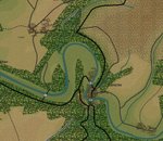
The result was a fairly large chunk of land, about 338 square kilometers, stretching from Allied jump-off point to just south of the St. Lo - Lessay road, and reaching from the Taute River to just east of the Vire. The map includes St. Lo in the bottom right hand corner. There is a ample road network, as well as river crossings and some varied elevation. Again, the main feature is the bocage.
Additionally, the battle narrative for this region provides ample excitement, with allied advances and SS counter-attacks. The actual duration of the battle was 12 days in the middle of July 1944. But more on the battle and the forces later.
After layering together the maps show above in Photoshop, I saved the file as a .bmp so it could be imported into the Map Maker tool. Then, I calculated the size of the area as best I could and created a new map file in the Map Maker to accomodate the size of my map. I then imported the .bmp by following the instructions in the game manual and I was ready to start creating the elevation layers, roads, towns, waterways, etc.
Once I bought the game, I set about creating the map. I wanted to maximize the area of the covered as much as possible so I chose several of the more detailed maps and quilted them together in Photoshop. I used different colors for each map to sort of align them better.
The result was a fairly large chunk of land, about 338 square kilometers, stretching from Allied jump-off point to just south of the St. Lo - Lessay road, and reaching from the Taute River to just east of the Vire. The map includes St. Lo in the bottom right hand corner. There is a ample road network, as well as river crossings and some varied elevation. Again, the main feature is the bocage.
Additionally, the battle narrative for this region provides ample excitement, with allied advances and SS counter-attacks. The actual duration of the battle was 12 days in the middle of July 1944. But more on the battle and the forces later.
After layering together the maps show above in Photoshop, I saved the file as a .bmp so it could be imported into the Map Maker tool. Then, I calculated the size of the area as best I could and created a new map file in the Map Maker to accomodate the size of my map. I then imported the .bmp by following the instructions in the game manual and I was ready to start creating the elevation layers, roads, towns, waterways, etc.
Tuesday, September 07, 2004
Creating Terrain Elements - Part Three
As mentioned in previous posts, the tools and documentation provided with HTTR are great and give any owner of the game great latitude (and longitude?) in creating maps, updating terrain, and building scenarios.
However, now that I've turned a wrench on my mod, and scraped my knuckles a time or two in the process, I would have one thing that would make this process a tiny bit better.
More Terrain Element Options!
As mentioned, I've used the "Broken" terrain slot to create the hedgerow terrain element. This means, of course, that I must forgo any maps that are heavy in "broken" terrain because I gave that option up. It would be great, therefore, if, in future releases, we could have MORE terrain options and even some blank terrain elements to build upon.
As the series moves on from Holland to Greece, I can imagine that the developers have opted to give up "Polder" in favor of "Olive Grove." But they couldn't simply add "Olive Grove" without replacing another terrain element, or perhaps I'm not aware. So how about 10 more terrain slots to work with?
That's it. Really, I feel funny complaining about such things... just hoping that my 2 cents can help improve what is a really awesome set of mod tools.
So, for comparison, here are actual hedgerows:

And here are my hedgerows:

Next, I'll walk through my map from research and development to making the file available to anyone wanting to jump in give have a look in advance of the final project being released.
However, now that I've turned a wrench on my mod, and scraped my knuckles a time or two in the process, I would have one thing that would make this process a tiny bit better.
More Terrain Element Options!
As mentioned, I've used the "Broken" terrain slot to create the hedgerow terrain element. This means, of course, that I must forgo any maps that are heavy in "broken" terrain because I gave that option up. It would be great, therefore, if, in future releases, we could have MORE terrain options and even some blank terrain elements to build upon.
As the series moves on from Holland to Greece, I can imagine that the developers have opted to give up "Polder" in favor of "Olive Grove." But they couldn't simply add "Olive Grove" without replacing another terrain element, or perhaps I'm not aware. So how about 10 more terrain slots to work with?
That's it. Really, I feel funny complaining about such things... just hoping that my 2 cents can help improve what is a really awesome set of mod tools.
So, for comparison, here are actual hedgerows:
And here are my hedgerows:
Next, I'll walk through my map from research and development to making the file available to anyone wanting to jump in give have a look in advance of the final project being released.
Saturday, September 04, 2004
Creating the Mod - Terrain Elements, Part Two
I'm simultaneously working on the mod and writing about how I've done it. Hopefully these descriptions are of use to anyone that wants to create their own game modifications or build scenarios.
NOTE: Creating these mods (and maps and scenarios) is, for the most part, fairly straightforward because Panther supplies the tools and documentation with the game. Plus, at the HTTR forums, there is a scenario and mod message board where the creators promptly answer questions.
I last talked about how I created the tile using the existing "broken" (meaning broken ground) terrain tile that I felt could be sacrificed in my maps. I addressed the kinds of values I entered into the dialog box to get the effect I wanted, which determines the mechanics of the terrain elements: visibility, movement, and the effect of shell bursts. For this mod I'm also developing new terrain graphics, so the following are some things I learned that may be of help to others.
To give the map the look of the Normandy hedgerows, I've created a series of grids for the different zoom levels of the games. It was a trial and error process figuring out which tiles correspond to which zoom levels, but here for any other aspiring modders is the relationship:

I was quite happy with how the graphic looked initially, but Arjuna from Panther games pointed out that the field density might be a bit high for the zoom level. Good point. So, I created new tiles for the more "zoomed-in" levels, which, after some experimentation, I decided look best as a straight up and down grid. I'm not 100% happy with it yet, but the grid at least doesn't overwhelm the map - and it does its job, giving the player an idea of when they are in the hedgerows.
I also made the tile graphics two-toned so that they would show up at any elevation. The trick was to introduce a dark brown row of pixels next to the green, as seen (barely) below:

For those of you that want to create new terrain graphics - it's important to make a corresponding set of grayscale graphics on the second map interface called "MapPatA.bmp".
Here's how the most magnified zoom level looks:

Anyway – that’s all for now. Next post is part three of terrain were I toss in a couple of “wish list” items for this kind of work.
NOTE: Creating these mods (and maps and scenarios) is, for the most part, fairly straightforward because Panther supplies the tools and documentation with the game. Plus, at the HTTR forums, there is a scenario and mod message board where the creators promptly answer questions.
I last talked about how I created the tile using the existing "broken" (meaning broken ground) terrain tile that I felt could be sacrificed in my maps. I addressed the kinds of values I entered into the dialog box to get the effect I wanted, which determines the mechanics of the terrain elements: visibility, movement, and the effect of shell bursts. For this mod I'm also developing new terrain graphics, so the following are some things I learned that may be of help to others.
To give the map the look of the Normandy hedgerows, I've created a series of grids for the different zoom levels of the games. It was a trial and error process figuring out which tiles correspond to which zoom levels, but here for any other aspiring modders is the relationship:
I was quite happy with how the graphic looked initially, but Arjuna from Panther games pointed out that the field density might be a bit high for the zoom level. Good point. So, I created new tiles for the more "zoomed-in" levels, which, after some experimentation, I decided look best as a straight up and down grid. I'm not 100% happy with it yet, but the grid at least doesn't overwhelm the map - and it does its job, giving the player an idea of when they are in the hedgerows.
I also made the tile graphics two-toned so that they would show up at any elevation. The trick was to introduce a dark brown row of pixels next to the green, as seen (barely) below:
For those of you that want to create new terrain graphics - it's important to make a corresponding set of grayscale graphics on the second map interface called "MapPatA.bmp".
Here's how the most magnified zoom level looks:
Anyway – that’s all for now. Next post is part three of terrain were I toss in a couple of “wish list” items for this kind of work.
Friday, September 03, 2004
Creating the Mod – Terrain Elements, Part One
The cornerstone of this mod is the new Hedgerow terrain element. To create it, I used the existing “Broken” terrain element, which I felt would be one of the least used in the maps I wish to create.
I adapted the speed and visibility values of the “Broken” terrain element to give it the feeling of hedgerow fighting. What I did was give the element the visibility of the city and the speed of polder. I’ve since tweaked almost all of the settings to make the element a little more forgiving, and a little easier to spot in, and this seems to provide the right feel. I hope to get feedback on this when it is released.
The most noticeable and difficult thing about this new terrain is how, even over short distances, a unit will increase dramatically in fatigue, while unit cohesion goes right down the tubes. It makes mounting an attack difficult and wearisome.
All of which seems pretty accurate. The difficulty of bocage fighting was one of the main impressions I took away from Glover S. Johns' book The Clay Pigeons of St. Lo.
In the modified game, the units constantly seek to use the roadways rather than attack through the hedgerows. It's not what I expected, but it might be "realistic." This is supported in the War Department’s history of the battle, which records a warning from the commander of the 2nd Panzer to his men: "the possession of dominating height is often not as decisive as possession of traffic junctions."
Thursday, September 02, 2004
If there's a bustle in your hedgerow...
Hi Airborne Assault fans!
I've chosen to create a blog for this game because it will allow me to easily publish information about my Hedgerows! modification, which will introduce new terrain, new units, and new maps. So far, I've created one map for the game, based on the area of Normandy south of Carentan, between the Vire and Taute rivers.
It was there that the U.S. 30th Infantry Division fought their way southward to capture the heights above St. Lo, thus making it possible for the 29th U.S. Infantry Division to enter and occupy the city. The map info and much of the scenario info was taken from the U.S. Army's Center for Military History.
The key terrain feature of this map is the hedgerow. These run like lattice-work across the Normandy countryside, divvying up the land into thousands and thousands of enclosed fields. These hedgerows have been in existence for hundreds of years and are formidable 2-meter high earthen barriers topped with dense overgrowth. The Germans made excellent use of these natural fortifications and held the allied advance for several weeks.
The modifications I'm making are an attempt to capture something of the battle of the hedgerows using the really amazing game engine of Allied Assault. It will not be 100% accurate - it cannot be. I don't have access to the game's estabs. But it will be as good an approximation as possible and hopefully further extend the playability of this excellent game... at least until the new titles come out.
It's worth mentioning that Panther Games, the creators of Allied Assault, have announced plans for a Normandy-based game in the future. It will likely be available after they publish Conquest of the Agean this fall, and Battle of the Bulge next year. I hope to have a playable version of the modification, map and new units in September.
Please stay tuned.
Rooster
Subscribe to:
Posts (Atom)