Tuesday, January 30, 2007

Trying to Take Marvie


In a nutshell, here's what happened at Marvie:

Striking at Bastogne through Marvie was the mission given to KG Hauser, which consisted of Pz Lehr's 901 Pz Gren Regiment and the Pz IVs of the 6/130 Pz Coy. They attacked the hamlet on the evening of December 23rd, the night affording some protection from the Allied fighter bombers that ruled the skies in daytime.

Marvie was held by Team O'Hara, defending the NW corner with help from the 609th TD Bn and the 2d Bn of the 327 Glider Inf Regiment, which was positioned along the south. These units had been shelled all day when the bombardment suddenly increased and was followed by an infantry rush on the the hill to the south, which overlooked the town. The glider infantry detachment was surrounded and destroyed.

A German half track, followed by four tanks from the 6/130 tried to exploit this victory and travel down the hill into the town, but the halftrack leading the group was knocked out and blocked the path of the tanks.

At this point, 12 more German Panzers and Infantry tried to force their way through on the Arlon-Bastogne road, which ran through the town, but these where beaten before they reached the town.

After midnight, the Germans renewed their attack, and with an additional 15 Panzers supported by infantry, they were able to take the south half of Marvie. The cost to the Germans was 8 Panzers for the night's attack. The town lay divided as the morning light broke into the sky and it would remain that way for days to come.

To learn more about this battle, read Cole's chapter on Bastogne.
Tuesday, January 16, 2007

Marvie Mapping

To create an Airborne Assault map all you've got to do is open up the mapmapker utility that ships with the game.

Okay okay... it's not THAT easy. But it isn't rocket surgery either.

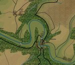
Below is an animated gif that shows the layers that have to be created to construct a map. Compare this gif with the map image below and you'll see the level of accuracy afforded by the Airborne Assault engine. This accuracy translates into in-game realism.


If you want to learn more about making a map, read this and then get started. If you run into trouble, post here. Lots of people want to help you.

The beauty, anyway, is in the finished product. If the game map matches the real terrain with any amount of accuracy, you've got the potential for facing the same problems that the commanders of the actual battle faced. This is one aspect of Airborne Assault that is unmatched in any other gaming system.

Next we'll look at the demands this kind of detail places on a commander in the Airborne Assault Engine.

Sunday, January 14, 2007

Maps & Map Creation

All of the tasks involved with creating scenarios require a lot of attention to detail, whether researching a scenario, creating historically accurate forces, or putting together the scenario itself.

Perhaps one of the most rewarding tasks is working on the game maps. The Airborne Assault engine utilizes extremely detailed maps. In many hex-based games, the maps are very good quality, but they don't have as much detail. A 1 km hex will have a list of attributes that generalize the terrain within that area. In Airborne Assault, the same 1 km x 1 km space will have up to 100 different types of terrain - all based on real maps from the period of the game.

Below is a 1943 U.S. Military Map showing the town of Marvie in the Ardennes. The town is just southeast of Bastogne and it was the location of significant fighting during the Battle of the Bulge as German forces sought to break through the defenses of the Bastogne perimeter and capture the city.


Looking at the map, one can see some significant tactical concerns for both the defender and the attacker. The small hamlet of Marvie lies in a draw and has a small stream which runs through it and another on its southern edge. There isn't much cover close-in - the woods are almost 1 km away in every direction.

An improved road runs east-west just to the north and east of Marvie - this will be one of the vital routes for the attacker. And it will mean that an attacking armored column will have to traverse a 2-3 km stretch that lies within 600 m of enemy guns. Within the town there is one minor road and 3 small roads.

To the south and the northeast, the terrain is higher than the hamlet. But with in the square km, there are six or seven changes in elevation. This will obviously be a strategic location within the game, just as it was within the actual battle.

Next we'll look at how the map will be portrayed in Airborne Assault: Battles from the Bulge.

Wednesday, December 20, 2006

Data Design Team Diary

A while back, I joined one of the Airborne Assault data design teams. More specifically, I joined the West Front data design team. That means I'm working on the upcoming Battles From the Bulge (BFTB) title, producing scenarios, editing force lists, researching battles, and sometimes working on maps. None of which is happening very quickly, because I'm a full time something else in the world of work, and a father of two young'uns at home.

But, I'm in all the way and hoping to learn something about developing a game. And, if you read this blog at all (I know updates haven't been happening in some time) you'll be able to learn a little too. I'm going to journal my experiences on the team and share some information about the development of the game.

None of the information is going to be a big scoop for anyone, so don't get your hopes up about me leaking game features and any other juicy tidbits. It's going to be a little more work-a-day scenario design stuff - not screaming tabloid headlines about new features. But I hope you'll get a look at what goes into the game and how the quality of the work makes the in-game experience worthwhile and enjoyable.

Thursday, July 20, 2006

It's a Mod Mod Mod Mod World

You can now get your map on with a handful of excellent terrain mods available at the COTA downloads page.